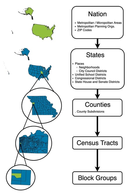
Geographies in mySidewalk
Check out the 16 different levels of geographies automatically included in the mySidewalk data library.
mySidewalk uses 16 distinct geographies to provide precise data insights.
These include:
- 13 Census geographies,
- 1 US Department of Transportation geography, and
- 2 geographies unique to mySidewalk (Neighborhoods and City Council Districts).
Key Features
-
Every dataset in mySidewalk has three characteristics: when, where, and what.
- Geographies answer “where” questions critical to community-focused insights.
Geography Nesting and Exceptions
Nesting Structure
Some Census geographies follow a nested structure, resembling Russian nesting dolls:
-
Blocks → Block Groups → Census Tracts → Counties → States.

Exceptions
But not all Census Geographies fit inside each other.
Place, ZIP Code, and Congressional District are 3 examples whose boundaries will not match Census Block Groups or Tracts.
Detailed overview of geographies
- Nation: Represents all 50 U.S. states and the District of Columbia. U.S. territories are excluded.
-
State: Includes all U.S. states and the District of Columbia.
-
County: Covers counties, parishes (Louisiana), and boroughs (Alaska). Exceptions include:
-
Cities acting as both county and city (e.g., Baltimore, MD).
-
Areas like parts of Yellowstone National Park not assigned to a county is made into a county.
-
-
Census Tract: Includes subdivisions of counties housing 1,200 to 8,000 people. This is updated during each decennial census.
-
Block Group: Includes Subdivisions of Census Tracts with 600 to 3,000 residents.
-
Place: Represents incorporated cities or Census Designated Places (CDPs).
-
This excludes some boroughs, towns, and other Minor Civil Divisions (MCDs) which instead are classified as County Subdivisions.
-
-
Congressional District: Defined by the 435 U.S. House of Representatives districts.
-
Metropolitan & Micropolitan Areas
-
Metropolitan: Urbanized areas with ≥50,000 people.
-
Micropolitan: Urban clusters between 10,000 and 50,000 people.
-
-
Metropolitan Planning Organizations (MPOs): Regions mandated for transportation planning by the Federal Highway Act.
-
Represent urbanized areas with populations over 50,000
-
-
ZIP Code: Approximates USPS delivery routes into boundaries called ZIP Code Tabulation Areas (ZCTAs). Please visit the Census website for more information on how ZCTA boundaries were created.
-
Note: Not all ZIP Codes are represented by a ZCTA.
-
When trying to map data collected by ZIP Code, you may have to use a crosswalk file to map the missing zip codes to the ZCTAs.
-
-
State Senate Legislative District: Areas electing state-level legislative members.
-
State House Legislative District: Areas electing state-level legislative members.
-
Unified School District (USD): Covers all grades in an area unless alternative school district types exist.
-
County Subdivisions: Primary divisions of counties and equivalent entities (e.g. boroughs and parishes). Includes minor civil divisions and unorganized territories.
-
Minor Civil Divisions (MCDs) in 12 states (CT, ME, MA, MI, MN, NH, NJ, NY, PA, RI, VT, and WI) are the equivalent of Place geographies.
-
-
City Council Districts (Built by mySidewalk): Represents local political boundaries used to elect council members.
-
Neighborhoods (Built by mySidewalk): Informal community boundaries defined by proximity to landmarks or transport.
Geography Updates and Vintage
Update Frequency
Geographies are annually updated.
Vintage
| Geography | Vintage |
| Nation | Last year of the most recent 5-year ACS |
| State | Last year of the most recent 5-year ACS |
| US Congressional District | 118th Congress of the United States |
| Metropolitan and Micropolitan Area | July 21, 2023 |
| Metropolitan Planning Organization | March 3, 2025 |
| County | Last year of the most recent 5-year ACS |
| State Senate District | 2022 Legislative Session Year |
| State House District | 2022 Legislative Session Year |
| Unified School District | Last year of the most recent 5-year ACS |
| County Subdivision | Last year of the most recent 5-year ACS |
| Place | Last year of the most recent 5-year ACS |
| City County District | Collected 2024-2025 |
| ZIP Code | 2020 Decennial Census |
| Neighborhood | Collected 2024-2025 |
| Census Tract | 2020 Decennial Census, with Connecticut county change |
| Census Block Group | 2020 Decennial Census, with Connecticut county change |
Tip: Notify your Customer Success Representative if your community’s geography changes.